Thomas Jefferson's Louisiana Purchase
The Mississippi River was the crux of the Louisiana Purchase. The United States had established a trade route along the river, which extends from Minnesota to the port city of New Orleans, La. The government had made an agreement with Spain, the country claiming the area from 1762 to 1800, to use the river trade route as it passed through Spanish-held territory. When Napoleon regained French control over this land in 1800, however, President Thomas Jefferson saw the necessity to secure the important Mississippi trade route for the United States.
Events Leading to the Louisiana Purchase
In October 1802, the king of Spain signed over the territory in question to France. Immediately, the Spanish representative in New Orleans locked American merchants out of the port city's warehouses, causing outrage and talk of succession. Napoleon made tentative plans to create a French settlement in the area.
Recognizing the need for diplomacy, Jefferson sent James Monroe to join U.S. ambassador Robert Livingston in France to negotiate the purchase of New Orleans. However, by the time Monroe arrived in Paris in 1803, the political situation had changed drastically. Facing a devastating loss of troops to yellow fever in Saint Dominque as well as the threat of imminent war with Britain, Napoleon had decided against colonizing the Midwest.
Lacking troops to defend the Mississippi valley for France, Napoleon made the decision to sell its interests there to the United States. By the time Monroe reached France's capital city, the deal was all but signed. The U.S. would get a far larger tract of territory than it had set out to buy.
The Agreement Between France and the United States
By the end of April, negotiations produced an agreement. The U.S. would purchase the entire Louisiana territory for $15 million, or about three cents per acre. The land consisted of 827,000 square miles. On October 20th, the U.S. Senate ratified the agreement with a vote of 24 to 7. By the beginning of 1804, the land transfer was complete.
The Louisiana Purchase on a Map
The land included in the Louisiana Purchase effectively doubled the size of the U.S. It encompassed what would one day become all or part of 15 states: Montana, North and South Dakota, Wyoming, Nebraska, Minnesota, Iowa, Colorado, Kansas, Missouri, New Mexico, Texas, Oklahoma, Arkansas and Louisiana. It originally included portions of Alberta and Saskatchewan, Canada, as well.
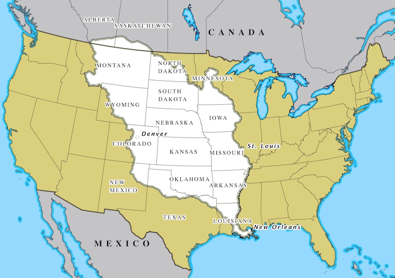
At the time of the transaction, France did not occupy any of the territory. In practice, it controlled only a small part of it, mostly along the Mississippi trade route. The vast majority of the land purchased by the U.S. was home to native tribes who did not recognize the right of ownership.
Thomas Jefferson and the Louisiana Purchase
Acquiring the land around the Mississippi River and beyond was one of Jefferson's most important contributions to the fledgling nation. However, he was concerned whether his approval of the purchasewas in keeping with the newly minted U.S. Constitution. Nothing in the document gave the president the specific power to make such a large expenditure, nor was there any mention of increasing the size of U.S. territory.
For a time, Jefferson was convinced that the Louisiana Purchase required a constitutional amendment. However, his closest advisors disagreed. Treasury Secretary Albert Gallatin asserted that the Constitution's provisions for making treaties validated the Louisiana Purchase. The Chief Justice of the Supreme Court, John Marshall, said that the Constitution gives the government the right to acquire land, either through conquest or treaty.
Lewis and Clark Expedition
Before the ink on the Louisiana deed was dried, Jefferson tapped his boyhood friend and secretary, Meriwether Lewis, to lead an expedition to explore the far reaches of the new lands. He was joined by William Clark. Their adventures, thanks to Thomas Jefferson, are history.